

Savoie Snow
Map · Snow cover · Alps

Snow cover map of the French Alps: satellite view

Where is there snow on the ground? This map shows snow cover as seen by the MODIS satellites, day by day. It shows where there is snow, not how much: for snow depths, see the observation stations.

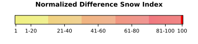
In short. The map shows snow cover (the NDSI index from MODIS, NASA), at a resolution of about 500 m with one pass a day. It is neither a snow depth nor a forecast, and clouds hide the ground. For measured depths, see the Météo-France stations on the Northern Alps snow page.

Loading data…

Understanding the conditions

Snow cover, snow depth, fresh snow and forecast

Snow cover tells you whether the ground is snow-covered at the spot seen by the satellite. Snow depth is a measurement in centimetres taken at an observation station. Fresh snow is snow that has fallen recently. A forecast comes from a model. These are four separate pieces of information; this map shows only one of them.

Measured snow depths: Northern Alps
Why are some areas left blank?

An optical satellite cannot see through cloud: an uncoloured area may be under cloud, not necessarily free of snow. Comparing the Terra and Aqua passes, or several days, helps fill the gaps. Above 3,000 m, terrain and light can also blur the index.

Which date should I choose?

The default date is yesterday, because today’s image is sometimes not yet published. Early in the season, snow cover spreads first at altitude; in spring, it retreats from the valleys upwards.

Your questions

Before you go

Does this map show how deep the snow is?

No. It shows snow cover, that is, where the satellite sees snow, not how deep it is.

Why are there blank areas on the snow cover map?

Clouds stop the satellite from seeing the ground. A blank area may or may not be covered in snow: the information is simply missing.

Where does the map come from?

From the “Snow Cover (NDSI, MODIS)” layer of NASA’s GIBS imagery services, with the layer’s official legend.

Where can I find measured snow depths?

On the Northern Alps snow page, which shows Météo-France’s observation stations with their dates.

Sources and method

Text of this page last revised on . This date says nothing about how recent the images or data are: the webcams are supplied by the credited operators and their timestamp shows when the image was taken; model forecasts and official reports are separate pieces of information, each with its own time.

Savoie Snow · Observe, understand, prepare.
Snow cover map of the French Alps: satellite view